

Southland (Māori: 'Murihiku') is New Zealand's southernmost region and is also a district within that region. It consists mainly of the southwestern portion of the South Island and Stewart Island / Rakiura. The region covers over 3.1 million hectares (28,681 square kilometers) and spans over 3,400 km of coastal stretch. Its two principal urban settlements are the city of Invercargill and the town of Gore. It has a population of 94,800, making it one of New Zealand's most sparsely populated areas. The sizable western part Fiordland is almost empty of permanent human inhabitation.
Southland is divided into two parliamentary electorates: the large rural electorate of Clutha-Southland and the seat of Invercargill. Under the Maori seats system, Southland is part of the large Te Tai Tonga electorate which covers the entire South Island and the surrounding islands.
Regional responsibilities are handled by the Southland Regional Council (Environment Southland). Three Territorial Authorities fall entirely within Southland. The Invercargill City Council governs Invercargill itself, together with some adjoining rural areas. Much of the remaining area of Southland, including all of Stewart Island/Rakiura, falls within the Southland District, which is administered by its own Council, also based in Invercargill. The Gore District Council administers the town of the same name and its rural hinterland. In 2001, three authorities (Invercargill City, Southland District and Gore District Councils) created the joint initiative agency Venture Southland which is the agency responsible for the region’s economic and community development initiatives and tourism promotion.
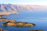
The region is home to two national parks: Fiordland National Park and Rakiura National Park. The former which covers 7,860 square kilometers is New Zealand's largest national park. Southland also includes Stewart Island, 85% of which is covered by Rakiura National Park. Southland contains New Zealand’s highest waterfall-the Browne Falls. Lake Hauroko is the deepest lake in the country.
Weather conditions in Southland are cooler and wetter than the other regions of New Zealand due to its distance from the Equator. Due to its closer proximity to the South Pole, the Aurora Australis or "Southern Lights" are more commonly seen than in other regions.
The region’s economy is based on agriculture, fishing, forestry and energy resources like coal and hydropower. The agriculture industry includes both sheep and dairy farming which both account for a significant proportion of the region’s revenue and export receipts. Southland also has the world’s largest raw milk-processing plant at the town of Edendale which was established by Fonterra. Other sizeable industries in Southland include coal and hydroelectric power. Southland contains the nation’s largest hydroelectric power station at manpouri which is owned by Meridian Energy. Eastern Southland has significant deposits of lignite which are considered to be New Zealand's biggest fossil fuel energy resource. Tourism spending is a major factor of the Southland economy.